

|
MARVLIS Server
Server functions as the hub of a complete communications system for the entire MARVLIS suite of products by interfacing directly with your CAD system to better manage resources and enhance the overall value of your system. Server receives location and status data from people and vehicles in the field, archives the data and distributes it to multiple monitoring applications in the dispatch center. Manage road closures and construction with an advanced barrier management system to improve routing, vehicle coverage and closest vehicle recommendations. Automated updates push application and data updates to your fleet without interrupting operations or consuming excessive staff time. |
|
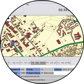
MARVLIS Client
Client is your in-vehicle connection to dispatch. Designed with the driver in mind, Client utilizes GPS and wireless communications to display realtime maps and routes recommended by MARVLIS Server as well as providing valuable information to empower the field worker for better performance. Take advantage of silent dispatch capabilities to receive full incident information including location, status and updates. Store multiple destinations such as headquarters, posts and hospitals for quick and simple routing. Field supervisors can access information about resources under their command, new incidents in the system and dispatch assignments. |
|
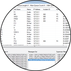
MARVLIS PSAP Monitor
PSAP Monitor is a multi-feature web interface for understanding MARVLIS Server data as well as integrating local ArcGIS and external web map sources that provide additional context of overall operations. This single web interface is designed for multiple user types including executives, administration, operational supervisors, and incident command staff. Specifically, it provides executive oversight of operations by quickly monitoring response times or unit availability and providing interactive access to current incidents and vehicle status across the fleet through a secure access from any web-enabled device. For administrators, these same features offer detailed information to impact performance measurements prior to regular reporting through insight into specific operational components for corrective actions in real-time. Operational supervisors have immediate insight into specific crews and incidents to provide guidance and oversight of operations. At the incident command level, PSAP Monitor provides hyper-local data on facility access or pre-plans within a larger regional context to keep an operational view across the region showing changing weather conditions, traffic, and potentially including mutual aid assets from adjoining jurisdictions. |
|
MARVLIS Deployment Planner
MARVLIS Deployment Planner automatically builds an accurate and efficient System Status Management plan to better deploy your resources for reduced response times and better service to the community. Using the historical demand data generated by Demand Monitor, Deployment Planner analyzes your demand, post locations and geographic coverage requirements to create a plan that best utilizes your resources for specific times of the day and week. The results of the analysis can be immediately used for deployment or can be imported into your CAD system for use as part of your overall management system. |
|
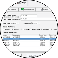
MARVLIS Impedance Monitor
Do you know the fastest route to an incident location? Depending on the time of day, day of the week or time of year that route may be different. MARVLIS Impedance Monitor constantly learns from your fleet’s AVL data and determines the true speed of travel over your roads and highways during different times of day. The resulting GIS data is then used to more efficiently recommend closest vehicles, route your vehicles to avoid traffic problems and more accurately calculate the true coverage of a vehicle for a specified response time. |
|
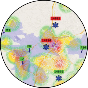
MARVLIS Deployment Monitor
Deployment Monitor is the only real-time analysis tool for the dispatch center that combines demand data, AVL, CAD information, traffic congestion and vehicle status to provide a complete overview of the effectiveness of your resource deployment. The operator is presented with a map that displays the hot spot map from Demand Monitor, overlaid with vehicle locations, vehicle status and coverage of each vehicle. Together, this information aids in the efficient management of resources to assure that the high probability areas can be covered by available vehicles yet minimizes the need for constant vehicle move-ups. |
|
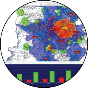
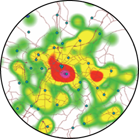
MARVLIS Demand Monitor
MARVLIS Demand Monitor is a new approach to managing call demand within your jurisdiction. Through automatic and regular analysis of the geographical and historical properties of data from your CAD system, Demand Monitor accurately predicts the location of upcoming calls. Demand Monitor increases your overall effectiveness by providing a map of the areas with the highest probability of calls, specific to your area, for the current time and season of year. |